
20250220175955.png)


Lot n° 22
Estimation :
80 - 100
EUR
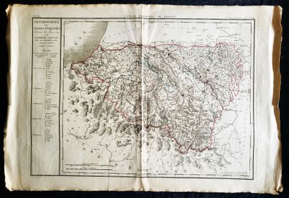
MAP - PYRENEES ATLANTIQUES / "Département des Basses-Pyrénée - Lot 22
MAP - PYRENEES ATLANTIQUES / "Département des Basses-Pyrénées, décrété le 8 février 1790 par l'Assemblée Nationale, divisé en 5 arrondissemens et 40 cantons", P.G. Chanlaire et Veuve Dumez: first printed map of this department, engraved by François d'Houdan for the Atlas National de France, first atlas of French departments, Years 1800, watercolor underlining in red and blue (tank 71.5 x 52 cm - total 86 x 58 cm)
My orders
Sale information
Sales conditions
Return to catalogue